Heights: AGL vs AMSL
Every height in Waveshed has an AGL / AMSL toggle. That applies to eye height and target height in LOS, or TX and RX height in RF. It answers “height above what?”.
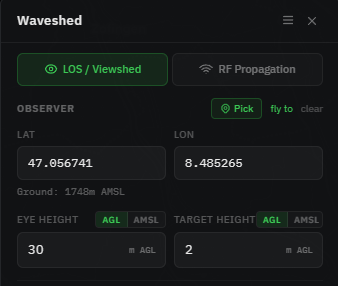
AGL: above ground level
Metres above the terrain at that point. This is what you usually want: eye level (≈1.7 m), an antenna’s height on its mast, or a building’s height. If the ground there is 1500 m and you enter 10 m AGL, the antenna sits at 1510 m absolute.
AMSL: above mean sea level
An absolute altitude, independent of the ground. Use it when you know the absolute figure: a summit elevation, or an aircraft/drone altitude. Waveshed shows the ground elevation at your point, and when you enter an AMSL height it shows the equivalent height above ground, so the two are easy to reconcile.
Frequently asked questions
What’s the difference between AGL and AMSL?
AGL (above ground level) is the height measured from the terrain at that exact point, like a 1.7 m eye level or an antenna on its mast. AMSL (above mean sea level) is an absolute altitude, independent of the ground, such as a summit elevation or an aircraft’s altitude.
Which height mode should I use?
When in doubt, use AGL. “How high above the ground is the antenna or eye?” is the natural way to think about most setups. Switch to AMSL only when you already know the absolute figure, such as a summit elevation or an aircraft or drone altitude.
How high should I set my antenna or eye height?
Use a realistic AGL value, such as roughly 1.7 m for eye level or your antenna’s height on its mast. If the ground sits at 1500 m and you enter 10 m AGL, the antenna ends up at 1510 m absolute, because Waveshed adds the terrain elevation for you.
Does Waveshed convert between AGL and AMSL?
Yes. Waveshed shows the ground elevation at your point, and when you enter an AMSL height it also shows the equivalent height above ground. That makes the two easy to reconcile, so you can work in whichever figure you already know.